|
Saving Map Documents
A map file (.mxd) is saved by selecting ‘Save’ or ‘Save
As…’ from the File menu. A map file contains only pointers
to the actual tables and shape files on your computer. All of the
views, layers, colours, joins, charts, layout arrangement, etc…
are defined within the map file. This means when you re-open a project
file all of the joins, and legends must be re-generated at that
time. Saving a map file does not modify existing data. By default
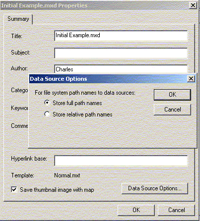
the map file contains absolute path names to each of the tables
and shape files. This means if you move any of your shape files,
tables, or change the name of any directories you will need to find
them again when you try to open the project. When you open a map
file, objects that are not found have an exclamation point ( ) beside them. You can re-assign the source location through the
layer properties under the Source tab. If you want to use relative
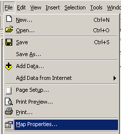
path names there is an option in the map properties found under
the file menu.
) beside them. You can re-assign the source location through the
layer properties under the Source tab. If you want to use relative
path names there is an option in the map properties found under
the file menu.
Save the current file as RHA.mxd (we will be going back to it later).
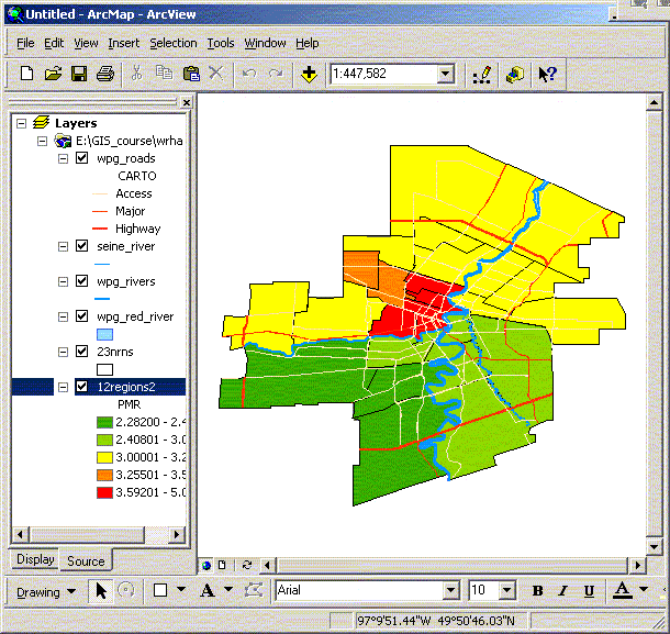
Activity 1. Basic Mapping of WRHA
Create and save a new map called WRHA that shows the 12 community
area (CA) regions (12regions2) of Winnipeg with Rivers (wpg_rivers,
wpg_red_river) and roads (wpg_roads) added. The appropriate files
are located in D:\GIS_course\wrha for shape files. Change the color
of the rivers to blue. Change the colors of the major roads based
on the Carto field (1- Residential streets, 2 – Access roads,
3 – Major through ways, 4 – Highway, 5 - path/lane).
You might want to change the maximum scale so the roads only show
up on larger scale maps (e.g. 1:50000)
Try mapping premature mortality (PMR) values for each CA. The PMR
values are already coded into the shape file.
Your map should look something like the following:
 Introduction
Basic Use: Layout View |
NEXT
 Map Projections
 |
|