Max Rady College of Medicine
Concept: MCHP Nine Winnipeg Sub-Regions
Concept Description
Last Updated: 2003-11-15
Introduction
-
In response to the criticism that analyzing all of Winnipeg together masks the "true" health status of residents in certain areas, an attempt to define Winnipeg sub-regions using a measure of socioeconomic status was made.
These sub-regions are based on the 1986 Census Family Income by Postal Code (see Income Quintiles Based on the 1996 Census for more information). Each resident of Winnipeg, as defined by the Dec. 1990 registry, was assigned an urban income quintile value according to his or her 6 character postal code.
A frequency of urban income quintile values by forward sortation areas (the first three characters of the postal code) was used to identify the "least wealthy" areas of the city: Inner Core (K1), Outer Core (K2), and Old St. Boniface (K3). The remaining areas, having similar urban income quintile distributions, were divided based upon the municipal and provincial Health Department jurisdictions, as well as on administrative offices established by the province within Winnipeg.
Nine Winnipeg Sub-Regions
-
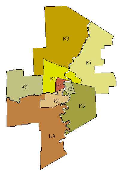
The resulting nine Winnipeg sub-divisions are as follows:
-
The following postal codes will assign the wealthier Middlegate area of R3C to Winnipeg sub-region South Central (K4):
R3C2C1-R3C2C9, R3C2E1, R3C2E2, R3C2E3, R3C3H3, R3C3H4, R3C1A1, R3C0Z7, R3C1S5
-
A number of Rural Route Delivery postal codes from the central downtown post office are re-assigned to the Winnipeg sub-regions North West (K6) or North East (K7)
-
R0C3A0, R3C2E5, R3C4A2, R3C4A3, R3C2E4, R3C2E8 = North West (K6)
R3C2E6, R3C2E7, R0E0H0 = North East (K7)
Region Name Forward Sortation Areas
K1 Inner Core R3A, R3B, R3C
K2 Outer Core R3E, R3G, R2X, R2W, R2L
K3 Old St. Boniface R2H
K4 South Central R3N, R3M, R3L
K5 West R3K, R3J, R3H, R2Y
K6 North West R2P, R2V, R2R
K7 North East R3W, R2C, R2K, R2G, R2E
K8 South East R2J, R3X, R2N, R2M
K9 South West R3R, R3S, R3P, R3Y, R3T, R3V
Several refinements were made to the sub-regions, using the entire six character postal code:
Map of Winnipeg Sub-Regions
Notes
-
Approximately 10,000 people, who were identified as Winnipeg residents, are classified as Non-Winnipeg residents by the 1986 Census. For example, residents just past the Perimeter Hwy. in West or East St. Paul would fall into this category. Urban income quintile values were therefore not available for these people. However, they all had a rural income quintile value of 5. Based upon the monetary ranges of rural quintile 5 and urban quintiles and using an assumption that the family income is equally distributed within the monetary range for rural quintile 5, an urban quintile value was randomly and proportionally assigned to these 10,000 people. This will be of more interest to analyses by income quintile.
-
Old St. Boniface includes approx. 13,500 people from a concentrated area of St. Vital (between St. Anne's Rd. and the Seine River, south of Fermor and north of Bishop Grandin) whose income was in the two lowest urban quintiles.
- Residents of the northeast corner of the Outer Core had a somewhat higher family income than the remainder of the Outer Core. They are included in the Outer Core because they, as do all of the Outer Core residents, fall within the City of Winnipeg Health Dept.'s jurisdiction.
Related concepts
- Income Quintiles Based on the 1996 Census
- Physician Service Areas (PSAs)
- Physician Service Areas (PSAs) That Fit Inside the Regional Health Authorities (RHAs)
Related terms
Request information in an accessible format
If you require access to our resources in a different format, please contact us:
- by phone at 204-789-3819
- by email at info@cpe.umanitoba.ca
We strive to provide accommodations upon request in a reasonable timeframe.
Contact us
Manitoba Centre for Health Policy
Rady Faculty of Health Sciences,
Room 408-727 McDermot Ave.
University of Manitoba
Winnipeg, MB R3E 3P5 Canada
204-789-3819