Max Rady College of Medicine
Concept: Regional Health Authority (RHA) Districts and Zones in Manitoba
Concept Description
Last Updated: 2013-12-17
Introduction
-
In Manitoba, a Regional Health Authority (RHA) is a regional governance structure set up by the provincial government to be responsible for the delivery and administration of health services in a specific geographical area. RHA Districts represent smaller geographical regions within an RHA. This structure was implemented across Manitoba in 1997 and continues today. Since its inception, the RHAs and corresponding number of districts within each RHA have changed. With the current structure of five RHAs, beginning in June 2012, each of the non-Winnipeg RHAs are divided into Zones and 70 distinct Districts.
This concept contains: a brief history of the change in RHAs and RHA Districts within Manitoba over time; a description of the methods of assigning individuals to RHA Districts; information on the SAS code developed at MCHP for working with RHA District geographical boundaries and assigning RHA Districts to the data for use in analyses; links to information in three different MCHP Deliverables focusing on RHA District-specific information (e.g. health indicators); links to additional resources/files for working with RHA Districts; and identifies some cautions/limitations when working with this type of data.
History and Changes in Manitoba RHA Districts
-
Andrea Zajac (Manitoba Health, Regional Support Services) provided initial district definitions on June 5, 2000. The initial districts were created in consultation between Regional Support Services and each RHA during 1999/2000. Further clarifications of districts, especially for RHAs with
unorganized territories
- (areas not organized into incorporated municipalities or First Nations reserves), were made during the summer and fall of 2001. Final discussions happened as part of the Need to Know meeting September 18, 2001. The use of these areas prior to 1997 fiscal year may not be valid, or should be used with some caution. Users should also be aware of changes to postal codes over time - additions, retirement and movement. The definitions of districts based on postal codes will need to be confirmed each year.
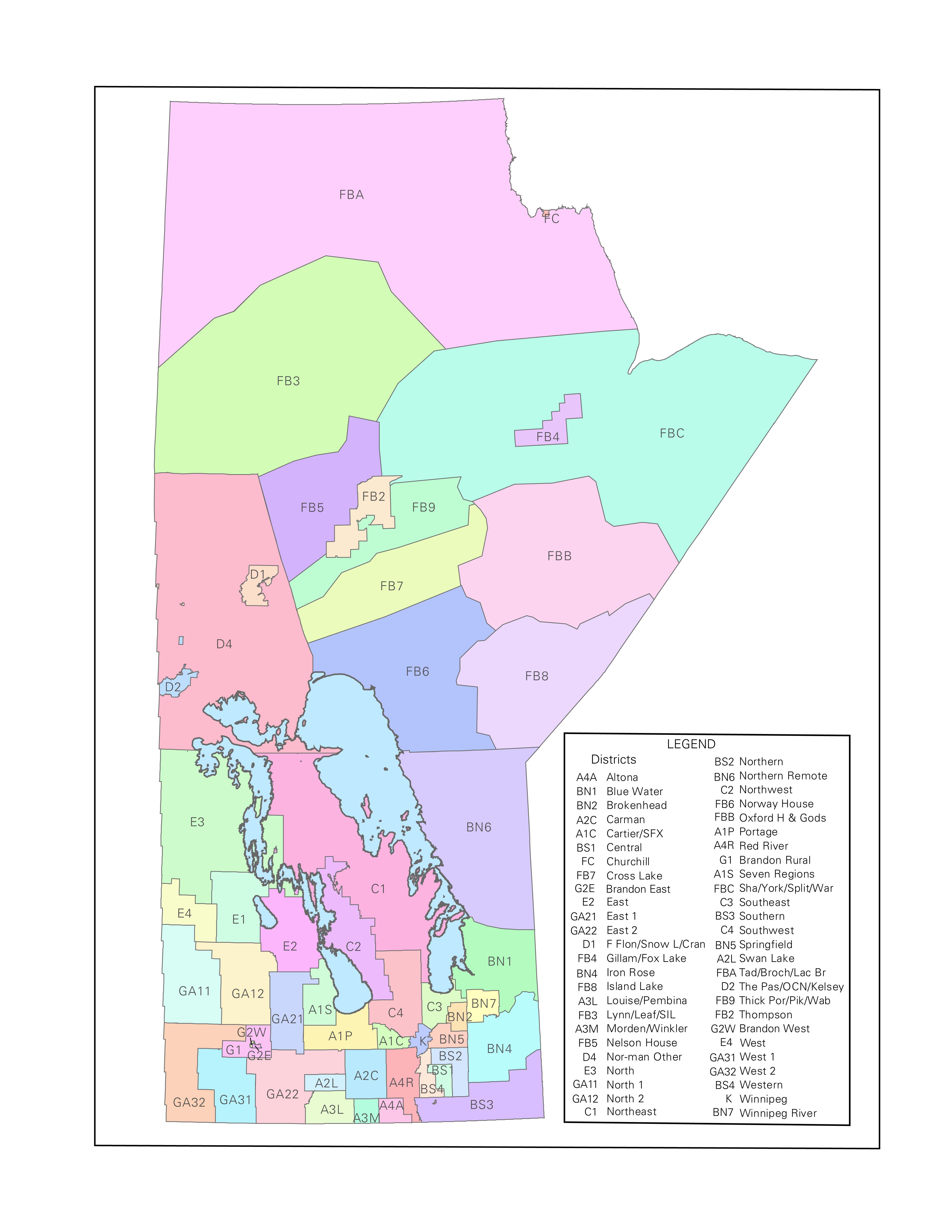
- List of 11 RHAs and RHA Districts in Manitoba - 2002 to 2012 NOTE: This list contains additional information on changes to Districts.
-
List of RHAs, RHA Zones and RHA Districts in Manitoba - 2012
from Appendix 1: Administrative Area Boundaries of
The 2013 RHA Indicators Atlas
deliverable.
NOTE: The "sub-regions" used by the Winnipeg Regional Health Authority (WRHA) are not called Districts. Sub-regions within Winnipeg are called Neighbourhood Clusters. The names of the 25 Neighbourhood Clusters and the neighbourhood / community centre areas that are part of each cluster in Winnipeg are included in a separate list as part of Appendix 1 in the link above.
In July 2002, South WestMan and Marquette RHAs amalgamated to form the Assiniboine RHA. In addition, during the fall of 2002, Assiniboine and Central changed the boundaries of their internal districts. Another change to the Central Districts, in the spring of 2004, was based on a request from Shelley Buchanan (April 4, 2004). On September 9, 2005 Nancy McPherson from Brandon RHA provided information on dividing Brandon city into 6 public health areas. The Brandon RHA provided a list of postal codes that belong in each area.
From July 2002 to June 2012, the structure of 11 RHAs and the number of RHA Districts in Manitoba remained relatively stable. For more information on RHAs and RHA Districts during this time period, please see:
In 2012, the number of RHAs in Manitoba was reduced from 11 to five and other geographical measures were introduced. Regional Health Authority (RHA) Zones were created that divide the non-Winnipeg RHAs into between three to seven geographic areas within a specific RHA. Each Zone contains a number of RHA Districts. Overall there are 16 Zones and 70 RHA Districts in the current RHA structure. For more information on Zones and RHA Districts since 2012, please see:
For more information on RHAs, please read the Regional Health Authorities (RHAs) in Manitoba concept.
For current information on RHAs from Manitoba Health, please see the Manitoba Health - Regional Health Authorities (RHAs) in Manitoba web site.
Method of Assigning RHA Districts / RHA Zones
-
MCHP assigns individuals to RHA Districts using the following process:
-
Assign districts initially based on municipal code as provided by Manitoba Health. First Nations (A-code municipal areas) are assigned based on postal/muncode combination (same assignment as MunOfPostal).
- Further definition of districts within some areas is based on the 6 digit postal code. In some systems at Manitoba Health full 6 digit postal codes are not available. In these cases the larger aggregations might have to be used. In some non-Manitoba Health systems municipal code is not available, or is estimated based on postal code.
-
List of 11 RHAs and RHA Districts in Manitoba - 2002 to 2012
- List of RHAs, RHA Zones and RHA Districts in Manitoba - 2012 from Appendix 1: Administrative Area Boundaries of The 2013 RHA Indicators Atlas deliverable.
The following links provide access to information on the RHA Districts definitions used in MCHP research over time.
SAS Macros, Formats and Labels
-
RHA District related SAS macros, formats and labels are available for defining and labelling the RHA Districts over time. All of the relevant files are located in either the system macro library or the system format library. Use the following guidelines:
-
use the
_rhad12.sas
macro and the
rhad12f
format if you are using the "new" 5 RHAs structure;
-
use the
_rhad05.sas
macro and the
rhadf
format if you are using the "old" 11 RHAs structure;
-
RHA Zones can be formed from the first three characters of the RHA District, using the SAS code ZONE = substr(rhad,1,3); and
-
use the
$rhal
format to label all RHA, RHA Zone and RHA District definitions.
NOTES:
-
The digits in the SAS® macro and format names refer to the relevant year of development, not the number of RHAs.
-
For more information, please see the Data Analyst Meeting Minutes available in the
LINKS section
(internal access only)
below.
- Please see the SAS Code and Formats section (internal access only) below for example SAS code relating to the RHA Districts.
NOTE: Examples of the SAS macro code, formats and labels are currently being updated and will be available shortly. For now, historical information is available (see below). -
The digits in the SAS® macro and format names refer to the relevant year of development, not the number of RHAs.
Historical SAS Code
The following is an example of the SAS macro call for calculating RHA Districts:
data pop98;The following are examples of the format and label file names that can be used to work with RHA Districts data from 2002 to 2012:set cpe.pop98 (where=( substr(postal,1,1)='R'));
_rhad05;
run;
- $rhadf - assignment of districts based on municipal codes.
- $rhadl - district labels.
- $burntf - assignment of communities that fall within the Unorganized territories of Burntwood. Some of these are assigned back to municipal code defined areas. Note : if numbers are too small then the following aggregations can be made: FB4 + FB9 - Gillam/Fox/Near Thompson, FBC + FBB + FBA - Remote. Two postal codes fall within Burntwood based on municipal values of 294 (Churchill, Pukatawagan). There is only a small number of these individuals, so they have been assigned to FBA.
- $brandf, $bran05f- assignment of Brandon districts (municipal area 026) is based on 6 digit postal code. The two formats represent the east/west areas and the newer public health areas. The east west generally following FSAs (R7A=East and R7B,R7A=West). There is overlap with R7A in West Brandon. The division generally follows the provincial electoral boundary - north along 18th to the river, east along the Assiniboine River to 1st, north along the first boundary of Brandon. This does not fit the electoral boundary exactly but it is close.
- $neastf - Assignment of unorganized territories and first nations communities based on 6 digit postal code in North Eastman.
- In NOR-MAN Cranberry Portage is divided from Kelsey by postal code.
- Two South EastMan postal codes are assigned to North Eastman (R0A2W0-Buffalo Point and R0E0N0-Falcon Beach) in some earlier data (pre 1997). Post 1996, Falcon Beach is assigned by municipal code (289).
RHA Districts Information in MCHP Deliverables
-
Many MCHP Deliverables provide information on indicators of population health status, healthcare use and quality of care at the RHA and RHA District level. This information is intended to assist RHAs in planning and administration of the health services and resources available in their area. The following three MCHP deliverables focus specifically on RHA content:
-
The Manitoba RHA Indicators Atlas
by
Martens et al. (2003)
-
Manitoba RHA Indicators Atlas 2009
by
Fransoo et al. (2009)
- The 2013 RHA Indicators Atlas by Fransoo et al. (2013)
The Manitoba RHA Indicators Atlas - (2003)
This report focuses on the non-Winnipeg RHAs; therefore Winnipeg is not included as one of the RHAs, except as a comparison at the bottom of selected graphs. Analyses for this project was completed prior to the amalgamation of South Westman and Marquette into the Assiniboine RHA, thus indicators are reported for 11 non-Winnipeg RHAs and their respective Districts. In this report, 51 non-Winnipeg districts were analysed. Most of the non-Winnipeg RHAs have between three to 11 sub-regional districts, with Churchill RHA being an exception. With just over 1000 residents, its rates are only generated for the region, not for any subdivision of that region. The following links are provided for easier access to information in this report:
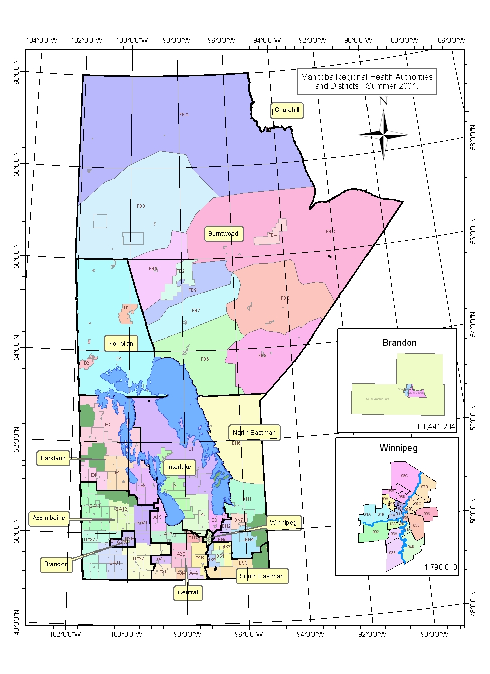
- Map of the Regional Health Authorities (RHAs) of Manitoba;
- Map of the Districts of Southern RHAs;
- Map of the Districts of Northern RHAs;
- Appendix 4: Manitoba Regional Health Authorities - Districts - describes the methods of developing Districts and lists the areas that fall within each district;
- List of Figures - provides a list for identifying the report indicators analysed by RHA and RHA Districts; and
- Data Extras - contains profile summary information of key indicators for RHA and RHA Districts, including demographic information, health status and mortality, illness burden, preventive services, child health, physician data, hospital data, high profile and discretionary procedures, home care and Personal Care Home (PCH) data, and pharmaceutical data.
Manitoba RHA Indicators Atlas 2009 - (2009)
This report provides data for all 11 RHAs in Manitoba, including Winnipeg, as well as the sub-areas within them. Non-Winnipeg RHA sub-areas are called Districts. Winnipeg is sub-divided into 25 Neighbourhood Clusters based on neighbourhood / community centre areas. The following links are provided for easier access to information in this report:
- Map of the Regional Health Authorities (RHAs) of Manitoba;
- Map of the Districts of Southern RHAs and Brandon RHA;
- Map of the Districts of Northern RHAs;
- Map of the Winnipeg Neighbourhood Clusters;
- Appendix One: Manitoba Regional Health Authority Districts & Winnipeg Community Areas and Neighbourhood Clusters - describes the methods of developing non-Winnipeg RHA Districts and lists the areas that fall within each RHA District and the neighbourhood /community centre areas that fall within the 25 Neighbourhood Clusters;
- List of Figures - provides a list for identifying the report indicators analysed by RHA, RHA Districts and Neighbourhood Clusters; and
- Data Extras - contains additional figures and tables on demographics, population health status and mortality, burden of physical illness, mental illness, physician services, hospital services, high profile surgical and diagnostic services, home care services, Personal Care Homes (PCH), preventive and other services, prescription drug use, quality of primary care, and results from the Canadian Community Health Survey (CCHS).
The 2013 RHA Indicators Atlas - (2013)
This report provides data for the five new Health Regions as well as the 11 former Regional health Authorities in Manitoba. For most indicators, there are "district-level" and "zone-level" analyses as well. In this report, 70 non-Winnipeg districts were analysed. For Winnipeg, analysis is provided by 25 Neighbourhood Clusters for most indicators and by 12 Winnipeg Community Areas for Personal Care Home (PCH) indicators. The following links are provided for easier access to information in this report:
- Map of Manitoba Health Regions and Former Regional Health Authorities;
- Table of Non-Winnipeg Health Regions, Zones and Districts;
- Map of the Zones and Districts for Southern Health Region;
- Map of the Zones and Districts for Prairie Mountain Health Region;
- Map of the Zones and Districts for Interlake-Eastern Health Region;
- Map of the Zones and Districts for Northern Health Region;
- Map of Community Areas and Neighbourhood Clusters for Winnipeg Health Region;
- List of Figures - provides a list identifying specific report indicators analysed and graphed by RHA, RHA Districts and Neighbourhood Clusters (you can link from this list to individual figures);
- List of Tables - provides a list identifying specific report indicators analysed and reported by current and former RHAs and by Winnipeg Neighbourhood Clusters (you can link from this list to individual figures); and
- Data Extras - contains supplemental figures and tables that were not printed in the report as well as additional material that can be downloaded. These files include information about changes in indicators of mortality and indicators of diseases and health conditions; maps of RHAs, RHA Districts and RHA Zones; and indicators on demographics, mortality, physical illness, mental illness, physician services, hospital services, surgical and diagnostic services, Personal care Homes (PCH), preventive and other services, and quality of primary care.
Additional Resources/Files for Working with RHA Districts
-
Map of RHA Districts - 2004 (pdf format)
-
Map of RHA Districts - 2004 (jpg format)
-
RHA Districts ArcView Shape file - 2004 (.zip format)
- RHA Districts ArcView Shape file - 2006 (.zip format)
Limitations / Cautions
-
Some of the datasets in the MCHP Data Repository contain variables collected by Manitoba Health that are related to RHAs or Regions in Manitoba (e.g. RHAMUN in the Hospital Discharge Abstracts 1997 APR dataset; REGION in the Management Information System (MIS) dataset). It is highly recommended that MCHP use the RHA Districts macro, format and label files developed by MCHP for any RHA level analyses because the "Manitoba Health" data can be quite different than the RHA data at MCHP
-
To limit the problems, assignment by postal code is done after the municipal code definition, and only for those that fall into the areas that need further division (e.g. Burntwood unorganized). Some postal code formats contain, for specific areas, postal codes outside of the community - e.g. Brandon (026) contains postal codes for a small number of individuals from Rapid City and Strathcona (R0K0C0, R0K1W0). There are a number of postal codes that have been included that have been retired (e.g. R8N0L0). Assignments of districts are based on Manitoba Health Insurance Registry files, Canada Post address ranges, and Statistics Canada Postal Code Conversion File (PCCF) files over the years. Districts with large numbers of postal codes, such as Brandon, were defined using a spatial join in ArcView between the defined region and the postal code centroid as defined in the PCCF file (June 2001) - very little verification has been done in these areas. Those districts with smaller numbers were assigned using a combination of files.
-
Out-of-Manitoba postal codes have been generally excluded. It is possible to be registered with Manitoba Health and have an out-of-province postal code but a Manitoba municipal code. Since these individuals will have a valid MB municipal code they can still be included with limited error unless they are assigned to an unorganized territory or other municipal area that is defined by postal code (e.g. Brandon). Individuals with a 900 municipal code are also excluded, since they cannot be assigned to an area and are not registered (generally) with Manitoba Health.
-
Users should be aware that one postal code in South Eastman (Buffalo Point - R0A2W0) is occasionally incorrectly located in North Eastman by the primary municipal code. This postal code may cause a small variation in numbers between North and South Eastman RHA and district values.
-
In May 1993 Headingley seceded from Winnipeg to become its own independent municipality. Prior to 1993, Headingley was part of Winnipeg (in muncode 320), and its residents were grouped into Winnipeg RHA. For 1993 and later they are grouped with Central RHA (muncode 321). For longitudinal studies spanning 92/93, it is probably best to assign Headingley to either Winnipeg RHA or Central RHA for the duration of the study. This avoids changes in the denominator which may affect the analysis. This can be done using the postal code R0H0J0. See the SAS code below:
* move postal=R0H0J0 rha='K' into Central;
if rha='K' and postal='R0H0J0' then do;rha='A';
* move postal R0H0A0, R0H1M0 into Parkland;
district='A4';
end;
if rha='A' and postal in('R0H0A0','R0H1M0') then do;rha='E';
district='E2';
end; - Other limitations noted in the Regional Health Authorities (RHA) in Manitoba concept apply to the definition of districts as well.
Related concepts
- Coronary Artery Bypass Surgery
- Health Regions in Manitoba
- Ordering By Premature Mortality Rate (PMR)
- Physician Service Areas (PSAs)
- Regional Health Authorities (RHA) in Manitoba
Related terms
- Neighbourhood Clusters (NC)
- Regional Health Authority (RHA)
- Regional Health Authority (RHA) Districts
- Regional Health Authority (RHA) Zones
- Winnipeg Community Areas (CAs)
Links
References
- Fransoo R, Martens P, Burland E, The Need to Know Team, Prior H, Burchill C. Manitoba RHA Indicators Atlas 2009. Winnipeg, MB: Manitoba Centre for Health Policy, 2009. [Report] [Summary] [Additional Materials] (View)
- Fransoo R, Martens P, The Need to Know Team, Prior H, Burchill C, Koseva I, Bailly A, Allegro E. The 2013 RHA Indicators Atlas. Winnipeg, MB: Manitoba Centre for Health Policy, 2013. [Report] [Summary] [Additional Materials] (View)
- Martens PJ, Fransoo R, The Need to Know Team, Burland E, Jebamani L, Burchill C, Black C, Dik N, MacWilliam L, Derksen S, Walld R, Steinbach C, Dahl M. The Manitoba RHA Indicators Atlas: Population-Based Comparison of Health and Health Care Use. Winnipeg, MB: Manitoba Centre for Health Policy, 2003. [Report] [Summary] [Additional Materials] (View)
Keywords
- geographic analysis
- RHAs
Request information in an accessible format
If you require access to our resources in a different format, please contact us:
- by phone at 204-789-3819
- by email at info@cpe.umanitoba.ca
We strive to provide accommodations upon request in a reasonable timeframe.
Contact us
Manitoba Centre for Health Policy
Rady Faculty of Health Sciences,
Room 408-727 McDermot Ave.
University of Manitoba
Winnipeg, MB R3E 3P5 Canada
204-789-3819