Max Rady College of Medicine
Concept: Neighbourhood Clusters (NC)
Concept Description
Last Updated: 2022-11-03
Introduction
-
Neighbourhood clusters (previously called Neighbourhood Resource Networks (NRN)) are one of two levels of areas developed by the Community Data Network with input from the Winnipeg Regional Health Authority (WRHA), Manitoba Health, Social Planning Council of Winnipeg, and others. The second, less detailed level of areas developed are called
Winnipeg Community Areas (CAs).
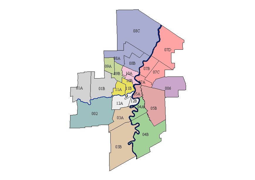
The Neighbourhood Clusters are used by Manitoba Health and the WRHA for planning and policy purposes. The 23 areas are those in the Winnipeg City Census Division. An additional two areas (for a total of 25) were added to represent East and West St. Paul. These areas have been assigned number-letter codes by the Community Data Network. MCHP has applied community names to these areas for reference and publication.
The following table contains the Neighbourhood Cluster codes and descriptions corresponding to the map on the right.
|
Neighbourhood Cluster
===================== 01A - St. James-Assiniboia W 01B - St. James-Assiniboia E 002 - Assiniboine South 03A - Fort Garry N 03B - Fort Garry S 04A - St. Vital N 04B - St. Vital S 05A - St. Boniface W 05B - St. Boniface E 006 - Transcona 07A - River East S 07B - River East W 07C - River East E 07D - River East N 08A - Seven Oaks W 08B - Seven Oaks E 08C - Seven Oaks N 09A - Inkster W 09B - Inkster E 10A - Point Douglas N 10B - Point Douglas S 11A - Downtown W 11B - Downtown E 12A - River Heights W 12B - River Heights E |
|
SAS Format
-
MCHP has developed a SAS® format "$wpg_nrf", that will convert a postal code to a Neighbourhood Cluster (NC) code for each of the 25 NCs. The format adds a "W" as a prefix to each of the NC codes listed above.
NOTE: An additional NC code of 21A can also be generated separately for Churchill, which is also part of the Winnipeg RHA.
Related concepts
- Community Centre Areas (CCAs)
- Crime Variable - Winnipeg Police Data
- Geocoding Addresses: Using ArcView
- Green Spaces Variable - Winnipeg
- Measures of Neighbourhoods
- Winnipeg Area Definitions
- Winnipeg Areas and Regional Health Authorities (RHAs)
- Winnipeg Community Areas (CAs)
Related terms
- Canadian Census Data
- Neighbourhood Clusters (NC)
- Winnipeg Areas
- Winnipeg Community Areas (CAs)
- Winnipeg Regional Health Authority (WRHA)
References
- Brownell M, De Coster C, Penfold R, Derksen S, Au W, Schultz J, Dahl M. Manitoba Child Health Atlas Update. Winnipeg, MB: Manitoba Centre for Health Policy, 2008. [Report] [Summary] [Additional Materials] (View)
Keywords
- geographic analysis
Request information in an accessible format
If you require access to our resources in a different format, please contact us:
- by phone at 204-789-3819
- by email at info@cpe.umanitoba.ca
We strive to provide accommodations upon request in a reasonable timeframe.
Contact us
Manitoba Centre for Health Policy
Rady Faculty of Health Sciences,
Room 408-727 McDermot Ave.
University of Manitoba
Winnipeg, MB R3E 3P5 Canada
204-789-3819