Max Rady College of Medicine
Concept: Winnipeg Community Areas (CAs)
Concept Description
Last Updated: 2022-11-03
Introduction
-
Winnipeg Community Areas are one of two levels of geographic areas developed by the Community Data Network with input from the Winnipeg Regional Health Authority (WRHA), Manitoba Health, Social Planning Council of Winnipeg, and others. The second, more detailed level of areas developed are called
Neighbourhood Clusters (NC).
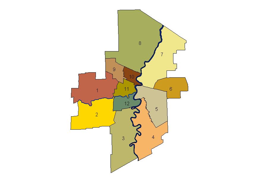
The 12 Community Areas are used by Manitoba Health and the WRHA for planning and policy purposes. They include the municipalities of East and West St. Paul.
The following table contains the Community Area codes and descriptions corresponding to the map on the right.
|
Winnipeg Community Areas
============================ 01 - St. James-Assiniboia 02 - Assiniboine South 03 - Fort Garry 04 - St. Vital 05 - St. Boniface 06 - Transcona 07 - River East (includes East St. Paul) 08 - Seven Oaks (includes West St. Paul) 09 - Inkster 10 - Point Douglas 11 - Downtown 12 - River Heights |
|
SAS Formats
-
MCHP has developed a SAS® format "$wpg_caf", that will convert a postal code to a Community Area (CA) code for each of the 12 CAs. The format adds a "W" as a prefix to each of the CA codes listed above.
NOTE: An additional CA code of 21 can also be generated separately for Churchill, which is also part of the Winnipeg RHA.
Population Size by Sex and Age Classification - Winnipeg Community Areas - 1998
-
The following table lists the population size by sex and age classification in Winnipeg Community Areas (CAs) in 1998. This information is based on information from Table II in
Brownell et al. (2002).
| Community Area (CA) | 0-4 Male | 0-4 Female | 5-9 Male | 5-9 Female | 10-14 Male | 10-14 Female | 15-19 Male | 15-19 Female | 20+ Male | 20+ Female | Total Population |
| Fort Garry |
1967
|
1852
|
2190
|
2149
|
2144
|
2076
|
2124
|
2012
|
21,396
|
23,352
|
61,262
|
| Assiniboine South |
958
|
947
|
1299
|
1289
|
1421
|
1388
|
1405
|
1262
|
12,369
|
14,118
|
36,456
|
| St. Vital |
2043
|
1930
|
2308
|
2063
|
2135
|
2049
|
1930
|
1908
|
20,799
|
23,739
|
60,904
|
| St. Boniface |
1374
|
1414
|
1518
|
1483
|
1422
|
1324
|
1494
|
1413
|
16,606
|
18,149
|
46,197
|
| River Heights |
1514
|
1495
|
1486
|
1408
|
1374
|
1347
|
1342
|
1327
|
20,700
|
24,968
|
56,961
|
| Seven Oaks |
1731
|
1687
|
1911
|
1825
|
1948
|
1874
|
1913
|
1979
|
20,036
|
22,567
|
57,471
|
| St.James-Assiniboia |
1727
|
1659
|
1820
|
1717
|
1690
|
1588
|
1725
|
1641
|
21,826
|
24,998
|
60,391
|
| River East |
2861
|
2751
|
3142
|
3032
|
3119
|
2960
|
3197
|
3001
|
31,756
|
35,285
|
91,104
|
| Transcona |
1185
|
1080
|
1349
|
1216
|
1293
|
1223
|
1182
|
1122
|
11,859
|
12,307
|
33,816
|
| Inkster |
1318
|
1113
|
1353
|
1237
|
1303
|
1259
|
1213
|
1168
|
10,370
|
10,873
|
31,207
|
| Downtown |
2707
|
2506
|
2536
|
2485
|
2262
|
2152
|
2061
|
2037
|
28,167
|
27,647
|
74,560
|
| Point Douglas |
1656
|
1563
|
1660
|
1561
|
1428
|
1371
|
1216
|
1214
|
14,323
|
14,529
|
40,521
|
| Winnipeg |
21,041
|
19,997
|
22,572
|
21,465
|
21,539
|
20,611
|
20,802
|
20,084
|
230,207
|
252,532
|
650,850
|
Related concepts
- Community Centre Areas (CCAs)
- Crime Variable - Winnipeg Police Data
- Factors Affecting Emergency Department (ED) Waiting Room Times
- Green Spaces Variable - Winnipeg
- Measures of Neighbourhoods
- Neighbourhood Clusters (NC)
- Winnipeg Area Definitions
- Winnipeg Areas and Regional Health Authorities (RHAs)
Related terms
- Neighbourhood Clusters (NC)
- Population by Winnipeg Community Area (CA)
- Winnipeg Areas
- Winnipeg Community Areas (CAs)
- Winnipeg Regional Health Authority (WRHA)
References
- Brownell M, Martens PJ, Kozyrskyj A, Fergusson P, Lerfald J, Mayer T, Derksen S, Friesen D. Assessing the Health of Children in Manitoba: A Population-Based Study. Winnipeg, MB: Manitoba Centre for Health Policy and Evaluation, 2001. [Report] [Summary] (View)
- Brownell M, De Coster C, Penfold R, Derksen S, Au W, Schultz J, Dahl M. Manitoba Child Health Atlas Update. Winnipeg, MB: Manitoba Centre for Health Policy, 2008. [Report] [Summary] [Additional Materials] (View)
- Brownell M, Mayer T, Martens PJ, Kozyrskyj A, Fergusson P, Bodnarchuk J, Derksen S, Friesen D, Walld R. Using a population-based health information system to study child health. Canadian Journal of Public Health 2002;93(Suppl 2):S9-S14. [Abstract] (View)
- Fransoo R, Martens P, The Need to Know Team, Prior H, Burchill C, Koseva I, Bailly A, Allegro E. The 2013 RHA Indicators Atlas. Winnipeg, MB: Manitoba Centre for Health Policy, 2013. [Report] [Summary] [Additional Materials] (View)
Keywords
- geographic analysis
- neighborhood
Request information in an accessible format
If you require access to our resources in a different format, please contact us:
- by phone at 204-789-3819
- by email at info@cpe.umanitoba.ca
We strive to provide accommodations upon request in a reasonable timeframe.
Contact us
Manitoba Centre for Health Policy
Rady Faculty of Health Sciences,
Room 408-727 McDermot Ave.
University of Manitoba
Winnipeg, MB R3E 3P5 Canada
204-789-3819