Max Rady College of Medicine
Concept: Winnipeg Area Definitions
Concept Description
Last Updated: 2004-07-24
Introduction
-
There are two levels of areas that have been developed by the Community Data Network with input from the WRHA, Manitoba Health, Social Planning Council of Winnipeg, and others. These are the areas that Manitoba Health and the WRHA will be using for planning and policy purposes.
-
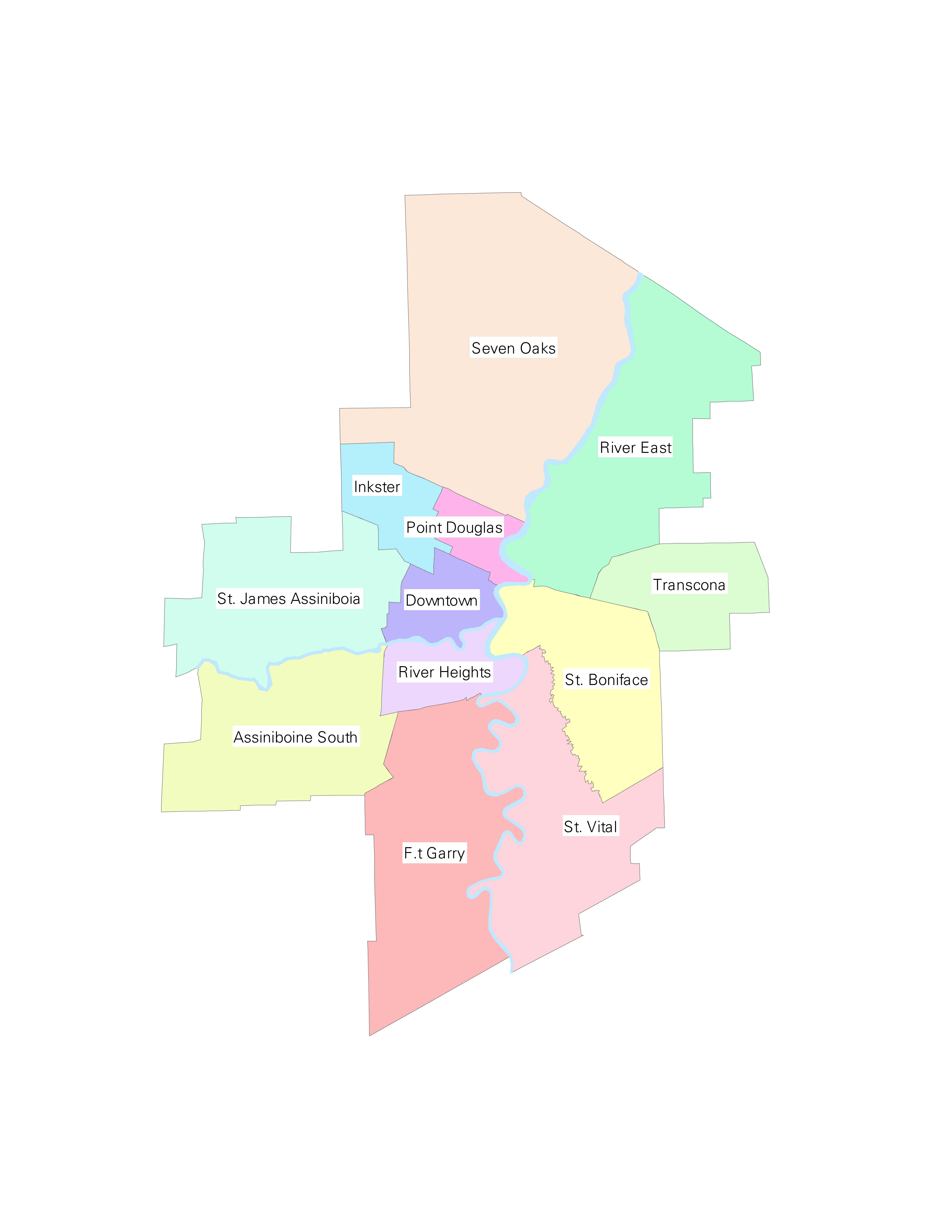
12 Community Areas (CA)
including East and West St. Paul, Assiniboine South (2), Downtown (11), Fort Garry (3), Inkster (9), Point Douglas (10), River East (7), River Heights (12), Seven Oaks (8), St. Vital (4), St. Boniface (5), St. James-Assiniboia (1), Transcona (6)
-
Community Areas Map
-
Map in PDF format for 2004
-
Map in JPG format for 2004
- ArcView Shape file as of 2006
For more detailed information, see the Winnipeg Community Areas (CAs) concept.
-
Community Areas Map
-
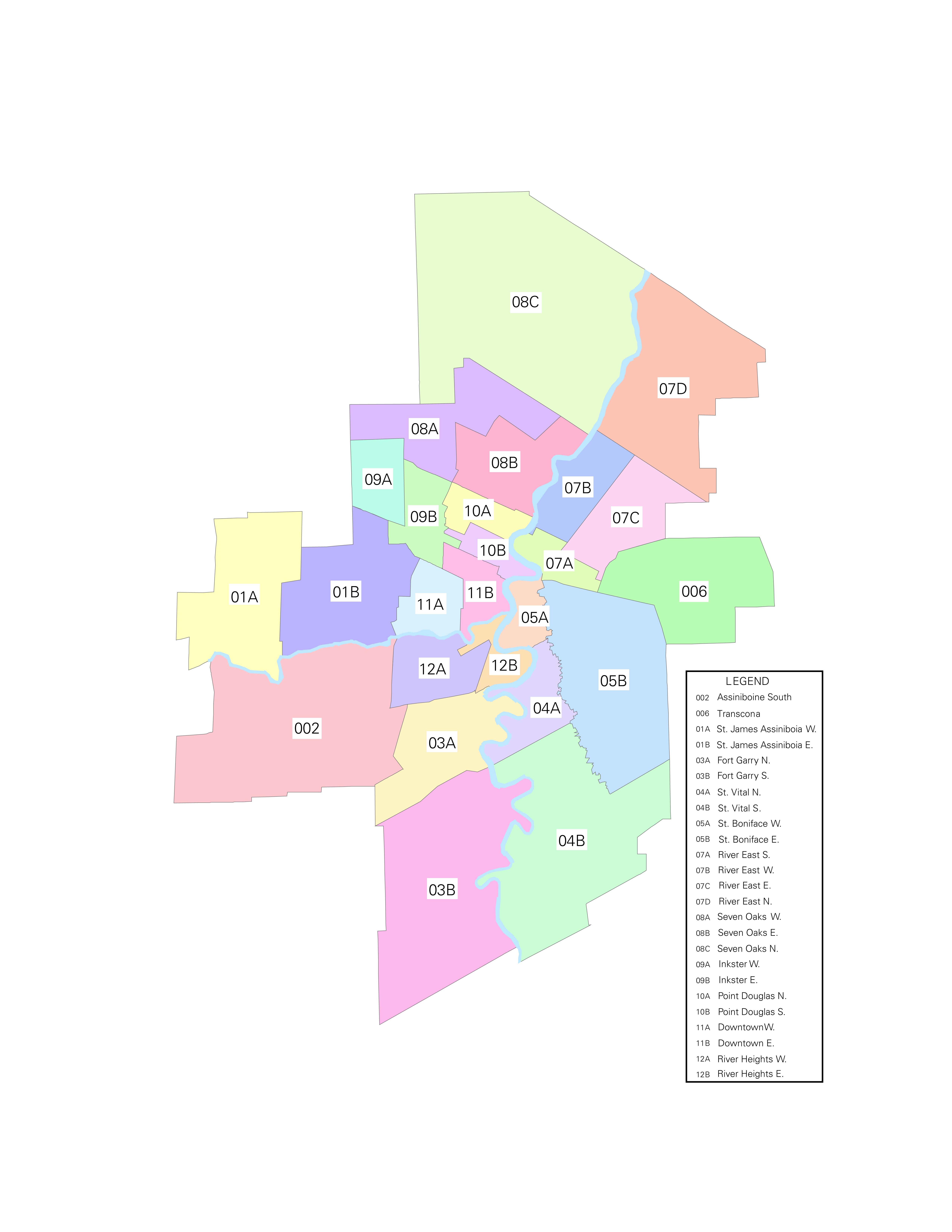
23 Neighbourhood Clusters
(previously called Neighbourhood Resource Networks (NRN))
The 23 areas are those in the Winnipeg City Census Division. An additional two areas (that makes 25!) have been added to represent East and West St. Paul. These areas have been assigned number-letter codes by the Community Data Network. MCHP has applied community names to these areas for reference and publication.
For more detailed information, see the Neighbourhood Clusters (NC) concept. -
Within the WRHA, there are 230 Neighborhoods.
-
In the late 1970's the City of Winnipeg initiated research on the "Winnipeg Area Characterization" project. This effort to categorize geographical areas sought to assist in a systematic approach to small area planning within the City. Using the notion that neighbourhoods are generally acknowledged as fundamental building blocks of the modern city, and that major thoroughfares, topographical features and existing land use demarcations are "natural" boundaries, the Area Characterization program set about defining a number of distinct neighbourhoods within Winnipeg.
-
The neighbourhoods defined through the Area Characterization initiative have served as the basis for data collection for several decades. In recent years, there has been a convergence of agreement among various agencies that neighbourhoods provide an ideal standardized measure for data collection.
-
Existing definitions for the "inner city" are based upon the aggregation of over thirty individual neighbourhoods. These inner city neighbourhoods are defined by their proximity to the central business.
-
District, age of housing stock, and general socio-economic conditions closely match the boundaries established for the Core Area Initiative during the mid 1980's.
Maps of these various areas can be found in the Various Areas of Winnipeg concept.
The areas have been defined by rolling up individual community neighbourhoods (230 of them) into relevant working areas for policy and planning. Documentation that provides information on how each of the areas were defined and on the reasons behind the boundary locations is being developed and will be posted here when available.
These Winnipeg areas represent:
The following is from the Social Planning Council:
Winnipeg Office of Public Trustee
-
In earlier work done by MCHP with the core area of Winnipeg we noticed high utilization of hospital days, and some measures of ill health (e.g. pre-mature mortality). While exploring this, we noticed that the bias was caused by a single postal code - that of the Winnipeg Public Trustees office. Unfortunately, the location of these individuals can not currently be confirmed - we do have some basic information with regard to distribution (not by individual) around the province. This information shows that these people do not necessarily live in Winnipeg but are spread across Manitoba. Including this postal code when locating individuals in geographical areas (downtown) skewed some data.
Manitoba Health Conversion Table for WRHA areas using Muncode + postal code
-
If both municipal code and postal code are available then the Manitoba Health conversion table (or formats) should be used if matching Manitoba Health numbers to assign Winnipeg Community areas. An
internal MCHP data dictionary is available for the wrha_cvt (aka the Conversion Table).
(internal access only)
.
-
MB-PCCF format for postal code only definitions have been added for first nations (A-coded) records.
- CA and NC values changed with a prefix of 'W' to distinguish from other formats used at MCHP.
The formats, and file information, must only be applied to the Winnipeg RHA ('K' or '10') based on the municipal code definition of the Manitoba RHAs. Records with an A-Code municipal code should be coded using postal code alone.
The following modifications have been made to the conversion table when creating formats:
Formats have been created for each year of data since 1996/97, but you will need to talk to Heather Prior about access to these formats.
See SAS Code below for format information.
Headingley
-
In May 1993, Headingley seceded from Winnipeg to become its own independent municipality. The Headingley Chamber of Commerce website explains that Winnipeg 'consistently under-serviced the community despite the substantial amount of tax' collected, prompting their decision to split off.
Prior to 1993 it was part of Winnipeg (in muncode 320), and its residents were grouped into Winnipeg RHA. 1993 and later they are grouped with Central RHA (muncode 321).
For longitudinal studies spanning 92/93 it is probably best to assign Headingley to either Winnipeg or Central for the duration of the study. This avoids changes in the denominator which may alter the results of your analysis. This can be done using the postal code R0H0J0.
* move postal=R0H0J0 rha='K' into Central;
if rha='K' and postal='R0H0J0' then do;
rha='A';
district='A4';
end;
SAS code and formats
Related concepts
- Community Centre Areas (CCAs)
- Crime Variable - Winnipeg Police Data
- Geocoding Addresses: Using ArcView
- Housing Variable - Winnipeg
- Measures of Neighbourhoods
- Neighbourhood Clusters (NC)
- Physician Service Areas (PSAs) That Fit Inside the Regional Health Authorities (RHAs)
- Public Trustee Office and MCHP Data
- Various Areas of Winnipeg
- Winnipeg Areas and Regional Health Authorities (RHAs)
- Winnipeg Community Areas (CAs)
Related terms
- Enumeration Area (EA)
- Municipal Code (MUNCODE)
- Neighbourhood Clusters (NC)
- Postal Code Conversion Files (PCCF)
- Winnipeg Areas
- Winnipeg Community Areas (CAs)
- Winnipeg Regional Health Authority (WRHA)
Links
- City of Winnipeg Web Site - 1996 Census Neighborhood Profile Data
- City of Winnipeg Web Site - 2001 Census Neighborhood profile Data
- City of Winnipeg Web Site - 2006 Census Neighborhood Profile Data
Keywords
- geographic analysis
Request information in an accessible format
If you require access to our resources in a different format, please contact us:
- by phone at 204-789-3819
- by email at info@cpe.umanitoba.ca
We strive to provide accommodations upon request in a reasonable timeframe.
Contact us
Manitoba Centre for Health Policy
Rady Faculty of Health Sciences,
Room 408-727 McDermot Ave.
University of Manitoba
Winnipeg, MB R3E 3P5 Canada
204-789-3819