Max Rady College of Medicine
Concept: Community Centre Areas (CCAs)
Concept Description
Last Updated: 2012-07-31
Introduction
-
Within the city of Winnipeg, 72 defined Community Centre Areas (CCAs) divide the city into relative segments that allow for geographical analysis and comparisons between the different CCAs. Typically, each CCA contains one or more community centre building or recreation centre.
History of Winnipeg Community Centres
-
Community Centre development in Winnipeg and the surrounding municipalities started to appear in 1946 when the city made $500,000 available for development of these areas. By 1960, there were 19 community centres, and this number grew steadily until the 1990's when a small number were closed or consolidated with others into a single administration.
This growth was spurred by the formation of the General Council of Winnipeg Community Centres (GCWCC) in 1971. The objectives of the GCWCC were to provide a central council where representatives from all community centres could meet to consider solutions to common concerns, to provide leadership and direction to all centres, and to provide an effective communication between the then Parks and Recreation Department, the Community Centres and the General Council.
In recent years, the Council has taken a much bigger role in providing volunteer support services in such areas as leadership development, reviewing and developing policy statements on all aspects of the operation of community centres, and being responsible to administer both Municipal and Provincial grant funding through five granting programs.
The GCWCC currently identifies 64 CCAs on their web site. The community centre names, along with addresses for mail, web sites and e-mail and phone and fax numbers are available in a document available on the GCWCC web site at: http://www.gcwcc.mb.ca/documents/CommunityCentreAddressBook.pdf
For more general information about the GCWCC, visit their web site at: http://www.gcwcc.mb.ca/ .
MCHP Defined Community Centre Areas
-
Over time, due to logistic and practical issues, the number of CCAs defined by MCHP has differed from the number of CCAs recognized by the GWCCC. In 2003, modifications were made to the original CCA boundaries for MCHP projects. First, a downtown area was added to the format (CCA 73). In addition, Robert A. Steen was divided into an East (CCA 491) and West (CCA 492), and Orioles was divided into an East (CCA 401) and West (CCA 402). For this reason, CCA 40 and CCA 49 no longer existed in this format. In this revision, formats were developed for defining 72 and 75 CCAs. Maps developed in 2003 identifying the CCAs and names of the Community Centres are available in the
Links section
below.
-
the Airport
-
Downtown
-
Railyards
-
Sage Creek
-
Waverly West
-
West St. Paul
-
East St. Paul, and
- South Perimeter
In 2012, the CCAs boundaries and definitions were revisited by MCHP staff. This work resulted in the redevelopment and identification of 72 distinct CCAs. In defining the geographical areas for CCAs, MCHP follows the boundaries for the 64 CCAs developed by the GCWCC. These boundaries are available in a document available on the GCWCC web site at: http://www.gcwcc.mb.ca/documents/CommunityCentreBoundaries_000.doc
Eight additional distinct areas were identified in 2012, including:
These areas all fall within the boundaries of the Winnipeg Regional Health Authority but were not identified or associated with an individual community centre (as defined by GCWCC). These areas were added to ensure that there was a capture of all locations within the WRHA boundary. These represent contiguous areas around the city that fit large geographic or regional areas. The names generally represent the area but are not defined, approved, or accepted by the GCWCC
A complete list of the 2012 MCHP identified Winnipeg CCAs areas with name and code are available in: Winnipeg_Community_Centre_Areas-2012-List-MCHP.pdf .
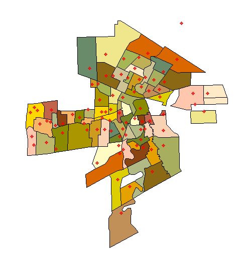
A map illustrating the 2012 MCHP identified Winnipeg CCAs is available either in pdf or jpg format:
Comparison of CCAs with Winnipeg Community Areas (CAs) and Winnipeg Neighbourhood Clusters (NCs)
-
Although the boundaries of the CCAs and the larger outer boundaries for the 12
Winnipeg Community Areas (CAs)
and 25
Neighbourhood Clusters (NC)
are the same for many of the CCAs, there are some differences in the intersections, particularly in the northwest region of the city. In these areas, some of the CCAs overlap two different Winnipeg Community Areas (CAs) or Neighbourhood Clusters (NC).
Formats and SAS Programming
-
The current formats for CCAs can be assigned using postal codes. The SAS code for assigning current formats and labels to the CCAs is:
_rha05; *** assign RHA based on muncode and postal code using the MCHP macro;NOTE: Previous methods for assigning CCAs use either postal codes or Enumeration Areas (EAs). The 2003 SAS code for assigning 72 or 75 CCAs using these previous methods is available in the SAS Code and Formats section below.
*** Assign CCA areas for WRHA only;
If rha="K" then do;CCA = put(postal,$cca2012f.);End;
Format cca $cca2012l.; *** Note code is not part of format label yet;
Cautions and Notes
-
There are several relevant cautions when working with CCAs.
1. Deer Lodge Centre and Riverview Health Centre
Preliminary work on the CCAs revealed very high premature mortality rates for particular CCAs that were not expected. The Deer Lodge CCA happens to contain the Deer Lodge Centre, home to many elderly residents. The postal code R3J 0L3 is used solely for the Deer Lodge Centre, and is the only postal code for the Centre. This postal code, therefore, is not assigned to the Deer Lodge CCA, but is instead assigned a null value (i.e., as if it was not within the boundaries of any community centre area). Likewise, for the format assigning CCAs based on enumeration areas, the enumeration area 46011065 is not assigned to that CCA. Of the 355 residents in the enumeration area, all are over the age of 50 and 80% are over the age of 70.
The Riverview Health Centre also created a bias for the Riverview CCA. The postal code R3L 2P4 and enumeration area 46013060 are also assigned null values.2. Winnipeg Office of Public Trustee
In earlier work done by MCHP with the core area of Winnipeg we noticed high utilization of hospital days, and some measures of ill health (e.g. pre-mature mortality). While exploring this it appeared a bias was created by a single postal code - that of the Winnipeg Public Trustee's office. The people who are represented by this postal code do not necessarily live in Winnipeg but are spread across Manitoba. You will want to eliminate this postal code from any analyses where this could be a problem.
See the Public Trustee Addresses - INTERNAL concept for more information about Public Trustee addresses and postal codes (internal access only).3. Winnipeg Child and Family Services (CFS)
A similar caution for work involving Winnipeg Child and Family Services (CFS) and CCAs is suggested here. For projects involving CFS and CCAs, consider excluding this data depending on the scope and purpose of the study.
See the Child and Family Services (CFS) - Postal Codes and Addresses in Manitoba - INTERNAL concept for more information about CFS addresses and postal codes (internal access only).
Additional Information
-
Additional information on Community Centre Areas (CCAs) is available in the
Winnipeg Quality of Life Project Phase One Report
from May, 2003.
SAS code and formats
Related concepts
- Crime Variable - Winnipeg Police Data
- Green Spaces Variable - Winnipeg
- Housing Variable - Winnipeg
- Measures of Neighbourhoods
- Neighbourhood Clusters (NC)
- Premature Mortality Rate (PMR) - Exclusion of Long Term Care (LTC) Facilities and Personal Care Homes (PCH)
- Public Trustee Office and MCHP Data
- Winnipeg Area Definitions
- Winnipeg Community Areas (CAs)
Related terms
- Community Centre Areas (CCA)
- Neighbourhood Clusters (NC)
- Winnipeg Areas
- Winnipeg Community Areas (CAs)
- Winnipeg Regional Health Authority (WRHA)
Links
- 2003 - Map of Winnipeg CCAs - 75 Areas
- 2003 - Map of Winnipeg Community Centres with Names - 72 Areas
References
- Frohlich K, Bodnarchuk J, Chateau D, Roos LL, Forsyth S. What you see is what you get? Questioning the relationship between objective and subjective appraisals of neighbourhood resources in relation to health. Can J Public Health 2007;98(4):292-296. [Abstract] (View)
Keywords
- geographic analysis
- neighborhood
- postal codes
Request information in an accessible format
If you require access to our resources in a different format, please contact us:
- by phone at 204-789-3819
- by email at info@cpe.umanitoba.ca
We strive to provide accommodations upon request in a reasonable timeframe.
Contact us
Manitoba Centre for Health Policy
Rady Faculty of Health Sciences,
Room 408-727 McDermot Ave.
University of Manitoba
Winnipeg, MB R3E 3P5 Canada
204-789-3819