ArcToolbox: BASIC USES
| Using ArcToolbox ArcToolbox is a set of utilities that is available for users to
do a variety of tasks from conversion of file types to spatial analyses.
ArcToolbox utilities are available directly within ArcMap starting
with ArcGIS 9.x. In this workshop we will only look at importing
ArcInfo export files and setting/changing projection information.
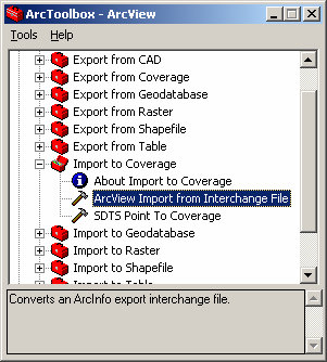
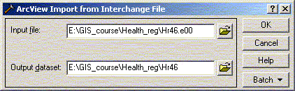
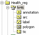
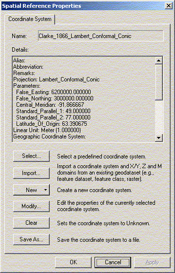
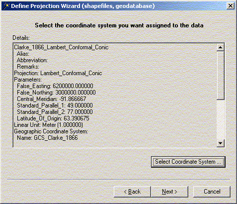
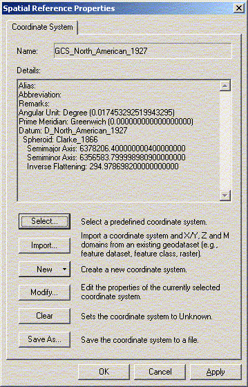
ArcToolbox can be opened by clicking on the toolbox ( Importing ArcInfo export (E00) files ArcInfo export files, with the extension .E00, are used by most groups to transfer ArcInfo data from one location to another. These file contain ArcInfo coverages. A coverage file is a special group of files used by ArcInfo. An ArcInfo coverage can contain more than one class of features. A polygon feature may also contain line features (arc) which store information about the boundaries between each polygon. To the user looking at the coverage file from Windows, coverages appear to be made up of two directories - the coverage directory (e.g. hr46) and an information directory (info). The group of files make up an ArcInfo coverage and includes a wide range of information including label points, polygons, lines (that make up the polygons), ticks, network information, projection, etc... Because coverage files are made of multiple parts they are not easy to transfer between systems so data providers create an ArcInfo export files when they want to move a coverage. Generally you will want to use ArcCatalog to move and edit GIS data sources. Most ArcInfo files that are available on the WWW or through the DLI (Data Liberation Initiative) are in ArcInfo export format (E00). These files have to be imported or converted from the single file export format to the multiple file coverage. When you open an imported coverage file, two new directories will automatically be created – the coverage directory and the information directory. The import program used to convert ArcInfo export files back into coverages is run from ArcToolbox by selecting Import to Coverage > ArcView Import from Interchange File. Because coverage files are made of multiple parts you will need to open just the part of interest. When viewing a coverage file from within ArcMap, Add Data or in ArcCatalog it will appear to have multiple parts (polygon, arc, annotation, label, point etc.). Many CAD files will show up in a similar fashion. Under ArcGIS 9 a number of the conversion tools that were part of the regular tool box have been moved. ARC/Info Interchange (Export) Format: This format, whose extension is usually .e00, will need to be translated into ARC/Info coverages. In version 9.x, access the the conversion utility by opening ArcCatalog and from the View menu add the "ArcView 8x Tools" toolbar. This also provides access to utilities to convert from MapInfo or SDTS (Spatial Data Transfer Standard) files, among others. Adding/Changing Projections If you know the projection or type of data that is contained in a shape file but it does not appear correctly with other shape files it is often useful to define the projection. This will allow ArcGIS to recognize the file and, within some limits, display multiple geographic data sources that are stored in different projections. Inside ArcToolbox select Data Management-> Projections -> Define Projection Wizard (shapefiles, geodatabase). Select the Health Canada RHA shape file saved from the hr46 coverage polygons. You might get a warning that a projection has already been defined. Click on the ‘Select Co-ordinate System’ button and Import the co-ordinate system used by the hr46 coverage file. If you know all of the projection information you can assign this by hand but by taking a quick look at the data fields you will quickly see this can be quite complex. Most of the data at the centre is stored in decimal degrees and can have the projection information set as North American Datum 1927 (Geographic Co-ordinate Systems -> North American -> North American Datum 1927). Geographic data associated with the 2001 census and most other sources can be assigned to North American Datum 1983 or WGS84.
|