| Here is what the ArcView Help
file has to say about UTM (Universal Transverse
Mercator):
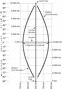
UTM - For the Universal Transverse Mercator
System, the globe is divided into sixty zones, each spanning six
degrees of longitude. Zones are numbered from west to east starting
at 180° longitude (the mid Pacific Ocean). Each zone has its
own central meridian. This projection is a specialized application
of the Transverse projection. The limits of each zone are 84°
N, 80° S.
Method of projection - Each UTM zone has
its own central meridian from which it spans 3 degrees west and
3 degrees east of that central meridian. The cylindrical methodology
is the same as that for the Transverse projection. Note that the
position of the cylinder rotates systematically around the globe.
X- and y-coordinates are recorded in meters. The origin for each
zone is the Equator and its central meridian. To eliminate negative
coordinates, the projection alters the coordinate values at the
origin. The value given to the central meridian is the false easting,
and the value assigned to the Equator is the false northing. For
locations in the Northern Hemisphere, the origin is assigned a
false easting of 500,000, and a false northing of 0. For locations
in the Southern Hemisphere, the origin is assigned a false easting
of 500,000 and a false northing of 10,000,000.
Lines of secancy - Two lines parallel to
and approximately 180 km to each side of the central meridian
of the UTM zone.
Linear graticules - The central meridian
and the Equator.
Properties
Shape - Conformal. Accurate representation
of small shapes. Minimal distortion of larger shapes within the
zone.
Area - Minimal distortion within each UTM
zone.
Direction - Local angles are true.
Distance - Scale is constant along the central
meridian, but at a scale factor of 0.9996 to reduce lateral distortion
within each zone. With this scale factor, lines lying 180 km east
and west of and parallel to the central meridian have a scale
factor of 1.0.
Limitations - Designed for a scale error
not exceeding 0.1 percent within each zone. This projection spans
the globe from 84° N to 80° S. Error and distortion increase
for regions that span more than one UTM zone.
 Projections
 |
|
|